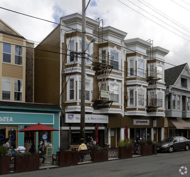
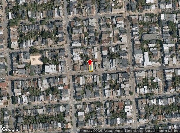
Property Record
3868 24Th St, San Francisco, CA 94114
NEARBY LISTINGS FOR SALE OR LEASE
Property Detail
3868 24Th St
San Francisco
Portion Of Horners Addition
San Francisco-Redwood City-South San Francisco, CA
BLK 87
3652-046
San Francisco
Apartment
California
2024
46
2025
0.05 AC
021100
Southern City
4,430 SF
DEMOGRAPHICS near 3868 24Th St
1 Mile
3 Mile
5 Mile
2024 Total Population
79,672
551,733
847,939
2029 Population
74,022
509,781
784,761
Pop Growth 2024-2029
(7.09%)
(7.60%)
(7.45%)
Average Age
42
42
42
2024 Total Households
36,149
234,136
353,858
HH Growth 2024-2029
(7.71%)
(7.95%)
(7.80%)
Median Household Inc
$163,466
$125,068
$124,149
Avg Household Size
2.10
2.20
2.30
2024 Avg HH Vehicles
1.00
1.00
1.00
Median Home Value
$1,115,355
$1,096,497
$1,093,542
Median Year Built
1947
1949
1949
Nearby Places
Map Layers
Map Styles
 Street
 Aerial
- Restaurants
- Banks
- Shops
- Fitness
- Groceries
PUBLIC TRANSPORTATION
TRANSIT/SUBWAY
Church And 24Th Street (J Church - San Francisco Municipal Railway (MUNI Metro))
DRIVE
WALK
Distance
Church And 24Th Street (J Church - San Francisco Municipal Railway (MUNI Metro))
0 min
1 min
0.1 mi
Church St & 24Th St (CHURCH - San Francisco Municipal Transportation Agency)
DRIVE
WALK
Distance
Church St & 24Th St (CHURCH - San Francisco Municipal Transportation Agency)
0 min
1 min
0.1 mi
Church And Clipper (J Church - San Francisco Municipal Railway (MUNI Metro))
DRIVE
WALK
Distance
Church And Clipper (J Church - San Francisco Municipal Railway (MUNI Metro))
1 min
4 min
0.3 mi
Church St & 26 St (CHURCH - San Francisco Municipal Transportation Agency)
DRIVE
WALK
Distance
Church St & 26 St (CHURCH - San Francisco Municipal Transportation Agency)
1 min
5 min
0.3 mi
Church St & 22Nd St (CHURCH - San Francisco Municipal Railway (MUNI Metro), J Church - San Francisco Municipal Railway (MUNI Metro))
DRIVE
WALK
Distance
Church St & 22Nd St (CHURCH - San Francisco Municipal Railway (MUNI Metro), J Church - San Francisco Municipal Railway (MUNI Metro))
1 min
5 min
0.3 mi
COMMUTER RAIL
22Nd Street Caltrain Station Southbound (Express - Caltrain (Caltrain), Limited - Caltrain (Caltrain), Local Weekday - Caltrain (Caltrain), Local Weekend - Caltrain (Caltrain))
DRIVE
WALK
Distance
22Nd Street Caltrain Station Southbound (Express - Caltrain (Caltrain), Limited - Caltrain (Caltrain), Local Weekday - Caltrain (Caltrain), Local Weekend - Caltrain (Caltrain))
9 min
3.5 mi
22Nd Street (Caltrain - Caltrain (Caltrain))
DRIVE
WALK
Distance
22Nd Street (Caltrain - Caltrain (Caltrain))
9 min
3.6 mi
AIRPORT
San Francisco International
DRIVE
WALK
Distance
San Francisco International
21 min
12.3 mi
Metro Oakland International
DRIVE
WALK
Distance
Metro Oakland International
36 min
21.9 mi
Freight Ports
Port of San Francisco
DRIVE
WALK
Distance
Port of San Francisco
12 min
4.3 mi
SALE & LEASE HISTORY
LISTING DATE
SALE/LEASE

Oct 11, 2022
For Lease
Nearby Properties
Address
Land Use
TOTAL SIZE
Lot Size
Zoning
Address
Land Use
TOTAL SIZE
Lot Size
Zoning
1,015,000 SF
2.43 AC
RC4
Address
Land Use
TOTAL SIZE
Lot Size
Zoning
750,370 SF
3.25 AC
MBR3
Address
Land Use
TOTAL SIZE
Lot Size
Zoning
248,303 SF
4.35 AC
Address
Land Use
TOTAL SIZE
Lot Size
Zoning
717,234 SF
3.47 AC
UMU
Address
Land Use
TOTAL SIZE
Lot Size
Zoning
475,791 SF
0.55 AC
C3OSD
Address
Land Use
TOTAL SIZE
Lot Size
Zoning
10.92 AC
Address
Land Use
TOTAL SIZE
Lot Size
Zoning
266,143 SF
4 AC
C-3-R
Address
Land Use
TOTAL SIZE
Lot Size
Zoning
885,581 SF
5.20 AC
M2
Address
Land Use
TOTAL SIZE
Lot Size
Zoning
508,714 SF
1.29 AC
C3R
Address
Land Use
TOTAL SIZE
Lot Size
Zoning
696,431 SF
0.97 AC
C3G
Address
Land Use
TOTAL SIZE
Lot Size
Zoning
139,070 SF
0.64 AC
C3O
Address
Land Use
TOTAL SIZE
Lot Size
Zoning
1.52 AC
C3G
Address
Land Use
TOTAL SIZE
Lot Size
Zoning
1,424,230 SF
2.60 AC
C3G
Address
Land Use
TOTAL SIZE
Lot Size
Zoning
263,640 SF
0.72 AC
C3R
Address
Land Use
TOTAL SIZE
Lot Size
Zoning
2.74 AC
Address
Land Use
TOTAL SIZE
Lot Size
Zoning
313,306 SF
1.23 AC
WMUG
Address
Land Use
TOTAL SIZE
Lot Size
Zoning
314,826 SF
1.85 AC
MB-RA
Address
Land Use
TOTAL SIZE
Lot Size
Zoning
922,758 SF
1.94 AC
C3R
Address
Land Use
TOTAL SIZE
Lot Size
Zoning
10.92 AC
Address
Land Use
TOTAL SIZE
Lot Size
Zoning
394,250 SF
0.63 AC
C3O
Address
Land Use
TOTAL SIZE
Lot Size
Zoning
393,918 SF
3.36 AC
WMUG
Address
Land Use
TOTAL SIZE
Lot Size
Zoning
24.37 AC
Address
Land Use
TOTAL SIZE
Lot Size
Zoning
241,659 SF
3.76 AC
Address
Land Use
TOTAL SIZE
Lot Size
Zoning
230,853 SF
3.76 AC
Address
Land Use
TOTAL SIZE
Lot Size
Zoning
342,574 SF
0.54 AC
C3O
Address
Land Use
TOTAL SIZE
Lot Size
Zoning
302,084 SF
0.88 AC
MBO
Address
Land Use
TOTAL SIZE
Lot Size
Zoning
674,317 SF
3.36 AC
UMU
Address
Land Use
TOTAL SIZE
Lot Size
Zoning
319,119 SF
0.76 AC
Address
Land Use
TOTAL SIZE
Lot Size
Zoning
649,376 SF
0.93 AC
C3S
Address
Land Use
TOTAL SIZE
Lot Size
Zoning
222,000 SF
1 AC
MB-RA
The World's #1 Commercial Real Estate Marketplace
Connect with us
© 2025 CoStar Group
The information above has been obtained from sources believed reliable. While we do not doubt its accuracy we have not verified it and make no guarantee, warranty or representation about it. It is your responsibility to independently confirm its accuracy and completeness. Any projections, opinions, assumptions, or estimates used are for example only and do not represent the current or future performance of the property. The value of this transaction to you depends on tax and other factors which should be evaluated by your tax, financial, and legal advisors. You and your advisors should conduct a careful, independent investigation of the property to determine to your satisfaction the suitability of the property for your needs.